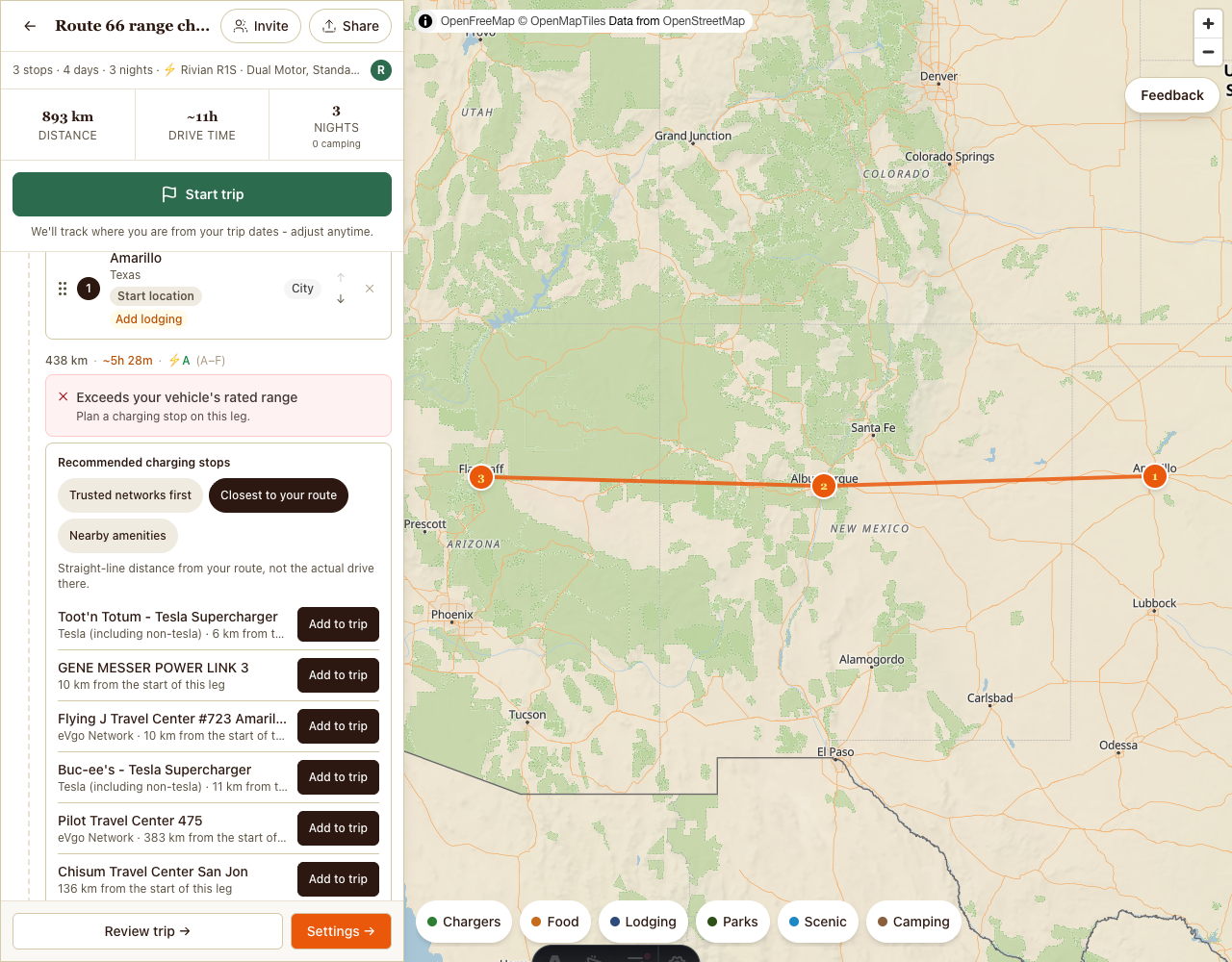
Photo by Roadbook. Map: OpenFreeMap, © OpenMapTiles, © OpenStreetMap contributors (ODbL 1.0). Chargers: Open Charge Map
Every road trip has one leg you think about before you leave. The long one, where the next town is a guess and the next charger is a hope.
On September 7, Nathan Byrnes sent us a detailed review of the Roadbook planner. It showed us that the planner did not think about that leg the way a driver does. We filed the review as 19 issues the same day. The last one closed on September 17.
The September 14 update lists what shipped that week. This post is about how the charging changes work on the road, and where they still fall short.
What the review found
The planner treated a day that is merely long and a day your car cannot drive on one charge as nearly the same thing. They are not the same. One is tiring. The other strands you.
Finding a charger, or any stop, meant already knowing what to search for. And a handful of labels asked you to guess what they meant.
The planner now flags the leg your car can’t make
If a leg is longer than your vehicle’s rated range, the planner puts a red alert on it: “Exceeds your vehicle’s rated range.” Under it: “Plan a charging stop on this leg.”
Know its limit before you trust it. The planner measures each leg in a straight line between its two stops and compares that to rated range. Roads bend around mountains and lakes. A road is never shorter than a straight line, so a leg can still need a charge without the alert. Treat the alert as a floor, not a promise.
Chargers for that leg, right under the alert
On a trip you own or can edit, a card under the alert lists charging stops for the leg. They are DC fast chargers from Open Charge Map, each with an “Add to trip” button.
You can put trusted networks first or sort by how close a charger is to your route. Or sort by nearby amenities. That one came from the review: if you have to stop here to charge anyway, is there food or a park close by? A charging stop can be lunch, or a walk, instead of a parking lot.
The card only lists chargers within your car’s rated range of where the leg starts, again measured in a straight line.
How well the list fits your car depends on what we know about it. When the trip’s vehicle has known connector types, the card keeps only chargers with a DC fast connection that fits. When we do not know the connector for that vehicle, the card cannot filter, and it lists every DC fast charger in range.
Will this charger take my car?
The review asked for this in plain terms: tell me whether a charger will work without making me learn connector types first.
In the planner’s nearby chargers list, when your trip has a vehicle and a charger lists its connectors, the row says “Compatible with your” or “Not compatible with your” followed by your car’s model. The connector chips stay below it for anyone who wants the detail.
It works for many models, not all of them. We record the car’s own inlet and do not count adapters. Where a model’s inlet changed between years, we leave the connector unknown rather than guess, and those cars get no label and no filter. Being told “Compatible” at a charger that will not take your car is worse than no label at all. The label appears only in the signed-in planner. It does not appear for guests or on public trip pages.
Browse the route without knowing what to search for
“Find a Place” works when you already know the name. On a road trip you often do not. You know you will want dinner somewhere past the pass, and a campsite before dark.
On a trip you own or can edit, the planner map now has six chips: Chargers, Food, Lodging, Parks, Scenic and Camping. Turn one on and matching places show up along your route.
The map and the charger list now move together. Pick a charger in the list and its pin highlights on the map, and the other way around. The trip owner can add a charger to the route straight from its map pin.
Smaller fixes from the same review
- In the planner, “Departure” is now “Start location” and “Drive in” is now “Drive time”.
- National Park and State Park are spelled out for screen readers.
- Trips can have an end date as well as a start date.
- The Budget and Trip Type pickers say what they change.
- Apple Maps directions open on desktop.
- Deleting a trip asks “Remove” or “Cancel” instead of “OK”.
What is still open
- The Chargers chip shows DC fast chargers only, not Level 2.
- The range alert and the charging card use straight-line distance, not road distance.
- Cars with an unknown connector get no compatibility label and no filter on the charging card.
- Removing a single stop still uses the browser’s “OK” and “Cancel”.
How we listen
Roadbook has a feedback button with three choices: Bug, Idea and Confusion. A detailed review like this one is the other way in. It shows us the roads we miss when we only plan our own trips. Thank you, Nathan.
Start planning your next EV road trip. Sign in to save it. Add your car, and the planner flags any leg longer than its rated range before you are out there on it.
Screenshot credits: map by OpenFreeMap, © OpenMapTiles, map data © OpenStreetMap contributors under ODbL 1.0. Charger data from Open Charge Map.